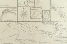
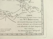
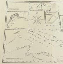
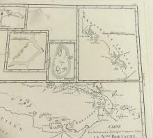
CARTE DE LA NLLE BRETAGNE, 1788


LOT DETAILS
A rare original interesting and detailed copper-plate engraving by Jean Andre (Plate 136) from the work of M. Bonne, Ingenieur Hydrographe de la Marine, based on the accounts of Capt. Philip Carteret’s voyage in HMS Swallow accompanied by HMS Dolphin, from the 1774 French edition of James Hawksworth’s official 1772 accounts of the journals of Cook’s voyages, and published in Paris in the French 1788 edition of Rigobert Bonne’s "Atlas Encyclopedique" comprising 6 individual maps, the largest showing Nouvelle Guinee ou Terre Des Papous (land of the Papuans) and containing the full title of the whole map image “Carte des Decouvertes du Capite. Carteret dans La Nlle Bretagne, avec une partie du passage du Capite. Cook par Le Detroit de L’Endeavour et les decouvertes du Capite. Dampierre dans ces Passages”
In English, this is the Chart of the discoveries of Capt Carteret ( in HMS Swallow in 1767) in New Britain (as he sails from the East past Cape St. George on the southern tip of New Ireland, along its southern coastline and onward west), with the route of Lt Cook (1st voyage in HMS Endeavour) through the Endeavour Strait (and along part of the southern coast of New Guinea in September 1770), and the discoveries by Capt. (William) Dampier (1651-1715, in HMS Roebuck) through these islands (December 1699 into 1700, passing 3 active island volcanoes along the route); presented in very good condition, as a folding map, protected in clear film sleeve - image size 22.9 x 34.3cm (9 x 13 1/2in)
