RARE 16TH CENTURY MAP

LOT DETAILS
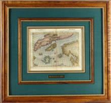
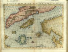
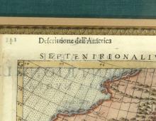
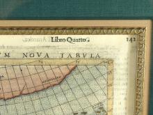
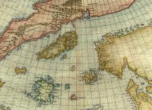
This original copper-engraved map by Giulio and Livio Sanuto was created by Girolamo Ruscelli in Venice in 1561 and published in his "Ptolemy's Geografia"; from Book 4 Descrittione dell'America, libro quarto, p.142. Italian text on verso; an elegantly engraved map with the sea in typical Ruscelli stippled manner, depicting Greenland and the North Atlantic, Iceland is central to the map; it is one of the most significant maps in his publication and is based upon the Zeno map of the North Atlantic from a pre-Columbian voyage to the New World in 1380 by Venetians Nicolo and Antonio Zeno
Of particular interest on this beautifully coloured plate is that it defines the area travelled by Zeno through Iceland to Frisland and Icara (both fictitious) to parts of North America, a claim later proved to be false; nonetheless, this map is considered to be one of the most captivating and intriguing maps in the history of cartography; image size 21.6 x 27.9cm (8 1/2 x 11in), frame outer dimensions 52.7 x 57.2cm (20 3/4 x 22 1/2in)